“Geologic maps have many uses, such as helping experts look for energy, mineral and water resources,” said Christopher Swezey, USGS National Cooperative Geologic Mapping Program coordinator. “They can also be used to assess earthquake risks and inform decisions about land use, infrastructure and community planning, and real estate and insurance.”
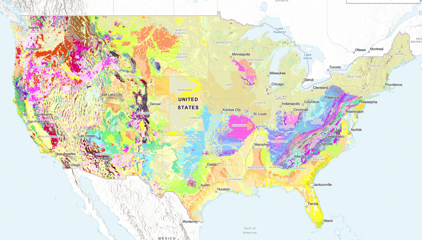
Geologic maps use different colors to show various types of rocks and sediments beneath the surface. These are organized into geologic map units, which range in composition from loose sand and gravel to very old bedrock. Each unit has its own unique characteristics, such as age and composition.
The new USGS map, called The Cooperative National Geologic Map, was created using more than 100 preexisting geologic maps from various sources and is the first nationwide map to provide users with access to multiple layers of geologic data for one location. This feature allows users to access the multiple data sources included in the map to look at or beneath the surface to understand the ancient history of the nation recorded in rocks. […]
“This map provides complete, analysis-ready geologic data for the nation, in a format that is easy to expand going forward” said Joseph Colgan, a USGS research geologist and leader of the team that created the map. “By providing this map online, we aim to enhance educational engagement and foster a greater public appreciation of geology.” […]
“Ongoing mapping efforts continually make new discoveries, but past national maps took decades to create while our new method allows us to update our national map faster than ever possible before,” said Sam Johnstone, a USGS research geologist and lead developer for the mapping project.
The success of this project is rooted in long-standing collaboration with state geological surveys, according to Dave Soller, senior program scientist for the USGS National Geologic Map Database. He noted that these partnerships have been instrumental in building stronger alliances and advancing more efficient methods for geologic mapping and data dissemination across the nation.
Read more here.


